The Pululahua Geobotanical Reserve was first created as a National Park on the 28th of January on 1966 via decree law No. 194. This was the first National Park created in Ecuador and in South America to protect this unique place.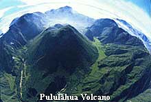
On the 17th of February 1978, this National Park was declared a Geobotanical Reserve via decree law No. 2559. This declaration was due to its geological uniqueness and great diversity with more than 2000 species of flora, great diversity of birds, mammals, and insects of exotic appearance.
The objective of this Reserve was to:
Protect the geology, flora, fauna, and water resources for future generations.
Preserve the resources of the area as a natural botanical garden.
It’s proximity to the “Mitad del Mundo” makes it a prime natural medium for scientific study, ambiental education, recreation, and tourism.
The Reserve has an area of 3383 hectares (8359.27 acres) with the following characteristics:
Range of Altitude: 1800-3356 meters (5906 to 11011 feet)
Temperature: Varies from 0 to 27 C (32 to 80 F)
Rain Fall: 500-3000 mm
Name: “Pululahua” is a Quichua word that means “cloud of water” or fog. This name is a good match to this caldera since every day it gets covered with fog--usually in the afternoon. The moisture comes from the west, the direction of the coast. The moisture travels north-east through the Guayllabamba river gorge and condenses in the form of fog when it enters the cool environment of the caldera.
Geological Description: It is a caldera formed from the collapsed volcano after it emptied it’s magma chamber during the eruptions dating back to 500 B.C., or 2500 years ago. This type of formation is typical of very strong eruptions that weaken the internal structure of a volcano. The caldera has three lava domes, Pondoña, El Chivo, and Pan de Azucar, which formed in the years following the eruption, and after the volcano collapsed. The highest elevation of this volcano is the Sincholagua hill on the north eastern side of the caldera at an elevation of 3356 meters.
The enormous strength of its eruption covered the coast of Ecuador with ash, destroying many cultures nearby and other far away such as Chorrera near Bahia de Caraquez, in the province of Manta. The ash covering most of the arqueological findings of the Chorrera Culture confirm the date and the effects of the Pululahua volcano eruption. This is clearly explained in Central Bank Museum in Bahia de Caraquez.
Pululahua of Today: “A peaceful paradise for the nature lovers”, “a jewel”, “a secret near Quito”, are some of the descriptions used today by the people that visit the reserve for the first time. This mystical place is also believed to have a great concentration of “Nature´s Energy” for being almost on the equatorial line and above an active volcano. The people, who live here, do not want to leave it, and the visitors always feel at peace and want to stay longer.
Surrounding the central lave dome called Pondoña are multiple agricultural terraces that have been producing the local crop for more than five hundred years. The mineral richness of the soil combined with the traditional ecological agriculture make this land very fertile, and the crop invariably organic.
All three lava domes and the steep walls of the caldera are protected areas and contain the great variety of fauna and flora that characterizes this mystical Geobotáincal Reserve.
FLORA
The Andes have more than 2900 endemic species; many of these are found in Pululahua, and for this reason, it is now a Geobotanical Reserve. 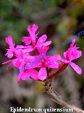
There are some sixty orchid species in this volcano. We have been collecting pictures for more than two years to develop a great picture-gallery of Andean orchids, which can help you identify them. Here is a list of the orchids identified so far: Pleurothallis truncata, Pleurothallis cordifolia, Odontoglossum hallii, Lycaste gigantea, Cyrtochilum macranthum, Sobralia sp, Oncidium sp, Epidendrum quitensium, Epidendrum medusae, Epidendrum geminiflorum, Epidendrum diothonaeoide, Epidendrum capricornu, Maxillaria aggregata, Maxillaria pardalina, Elleanthus capitatus, Cyrtochilum serratum, Oncidium heteranthum.
We also have an Andean Flower picture-gallery. This is a list of the flowers we have identified so far: Escobedia grandiflora, Mimosa albida, Salvia tortuosa, Calceolaria, Abatia parviflora, Phaedranassa dubia, Siphocampylus giganteus, Puya vestita, Bromerea hirsuta, Castilleja, Polygala, Guzmania jaramilloi.
FAUNA
More than five hundred years of human existence in the volcano have diminished the fauna population. There is no formal study of the fauna, but we know of the existence of the following groups: Sciurus granatensis (squirrel), Sylvilagus brasiliensis (rabbits); Mazana rufina ; (fruit bats), Lycalopex culpaeus (culpeo fox), puma (mountain lion), Tremarctos ornatus (Spectacled Bear or Andean Bear), Dasypus Novemcinctus (armadillo), Mustela frenata (Weasel).
There is also a great variety of insects, beautiful butterflies, and many colorful birds.
HISTORICAL SYNOPSIS: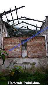
The last eruption caused the relocation and disappearance of cultures such as Cotocollao, Yumbos, and Chorrera. The Incas also had a short presence in the area and left a few remains such as Rumicucho, which is a military and religious fortress located at 6 km from the Pululahua Volcano. A few years after the Incas arrived, the Spanish also arrived and exploited the area setting up haciendas in Pululahua, Calacalí, Caspigasí and Tanglahua. These farms were handed over to the Religious Orders of “Los Dominicanos”, “La Comañía of Jesus” and the “Carmen Bajo” for their management and exploitation. In 1905, the Liberal Revolution in Ecuador led by leftist president Eloy Alfaro confiscated many farms such as Pululahua and handed them over to the “Asistemcia Publica” which was a branch of the government that help the poor people. This branch leased most of the lands, with the workers or slaves included, to private parties and use the money to build schools etc. In 1964 came the land reform which ended all of the land occupations that started with the Spaniards, and distributed the lands to the poor families that had been slaved in the Hacienda Pululahua. These workers are also known as huasipungueros. Most of the agricultural land inside of the crater still belongs to these poor families.
For a more detailed review of the History around this volcano click here.
ECONOMIC RESOURCES OF THE ZONE:
There is record of agricultural production since the occupation of the Spaniards. There is also record of activities such as extraction of lime, gypsum, gold, and silver. The ridge named “The Washer” apparently got its name because of the gold washing.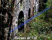
The extraction of calcium carbonate as lime was the main activity remembered by the oldest locals, and that many people came to work in the limestone kilns. It was similar to a gold rush. They say that hoards of mules were used to carry the lime out of the crater. We have found twelve limestone kilns in the Pululahua area. These are tall rock structures 3 to 5 meters tall and have an internal diameter of 1 to 1.4 meters. They look like a round chimney. The limestone was removed from the walls and carried by mules to the kiln. The limestone was loaded in the kiln and mixed with wood, and coal in different proportions. A fire was built underneath the kiln, which started the burning process until all of the wood and coal was consumed. This process lasted two to three days; in the end, the purified lime fell to the bottom where it was bagged. The lime was used in the construction of colonial Quito when the Spanish arrived in the eighteen hundreds. It is mixed with water and an adhesive to make a whitening paint used until today. Almost all of colonial Quito´s white walls are painted with this material. Lime is also mixed with sand, water, and clay to make a mortar like material used for joining rocks, therefore used for building rock walls. The importance of these basic building materials, for a growing city like Quito, made the limestone very important and expensive. This is why the old folks in the area say that lime was as expensive as gold.
Agriculture and Tourism are today´s main source of economic activity. Most of the local inhabitants of this crater live in poverty and depend on the land for food and income. Their cultivating methods have been developed by past generations and produce chemical-free food. The most common type of crop is the combination of corn with broad-beans, and squash. This type of crop has been cultivated by their ancestors for many generations and is identical to the practices used by the American-Indians. This type of crop is known in the United States of America as the “holy trinity”. The main advantage of this combination is a nutrient balance achieved by the introduction of nitrogen to the soil by the beans and squash, while the corn uses up most of the nitrogen. In industrial agriculture this has been replaced by the use of fertilizers.
AREAS OF INTEREST
Moraspungo 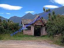
Moraspungo is a recreational area constructed by the Ministry of Environment. There are several trails, two cabañas, picnic areas, bathrooms, and an excellent view of the crater. Access is via the main park entrance on the paved road that goes to Calacalí. Park entrance fees are $1 for residents and $5 for tourists. If you are a resident, bring your “cedula” (Ecuadorian ID) to get your discount.
Hacienda Pululahua
This hacienda was built by the Spanish in 1825 and was managed by the Dominican Fathers. They exploited the workers and the bounty of this caldera until 1905. It is reported that the Indians were ill-treated and punished by whip for their mistakes and sins.
Hostal Pululahua 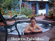
It is a beautiful, cozy and quiet lodge with cabins, rooms, and a capacity for 16 people. Each cottage has a private bathroom with hot water, a double bed and a bunk bed. There is also a whirlpool of hot water for eight people. There is a main house that has two rooms with a shared bathroom and living room with fireplace and the kitchen. It offers horseback riding, bike rental, and rappelling classes for beginners. The lodge also has an organic farm where they produce most of the ingredients that are used in its organic menu. It also has a vegetarian menu.
www.pululahuahostal.com
CEL: 091914333 mail: ![]()
The Pondoña Hill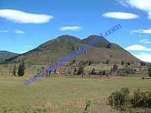
Is the central lava dome formed in during a later eruption 500 years after the volcano collapsed. There is also a small crater in the top eastern (frontal) side of the dome. This dome also has a trail that provides access to the area behind the hill. The views of the crater from the top of the trail are fabulous, and it is possible to see its own small crater.
The Chivo Rock
It is a smaller lava dome in the southern part of the crater which ends on a sharp point. There is a trail with access to the summit where there is space for two tents. The water trail starts at its base, where the water tanks for the community are installed, and continues southward to reach the watersheds. Here you will find many water tanks used to trap the mountain water that condenses in the highland cloud forest. Please do not foul the water, be careful not to cause any damage to this fragile ecosystem and water collection area.
El Mirador
It is an observation terrace at 2833 meters near the south west side of the caldera with access via paved road. It is has a great view of the front side of the caldera from which you can observe the agricultural west side, El Pondoña hill, El Chivo Rock, and some of the caldera walls to the North. You can also access the Reserve from El Mirador via 1.4 km foot trail that descends 300 meters to the bottom of the caldera.
Pululahua Comunnity (San Isidro)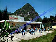
San Isidro is the official name of the community inside the caldera where more than one hundred and twenty owners share the 200 hectares of agricultural land. The community is spread out due to the municipal regulations that prevent using more than 1% of the land area as living or construction area. There are approximately sixty people living here, most of them are very poor and are either descendants of farm workers (huasipungeros), or are care takers. The community has a school house, “Escuelita Club de Leones”, where sixteen children attend a one-teacher school room. Also there is a small church that is only used a few times a year, only during special family services, since the priest charges $50 for each service. A communal house, where the community gathers once a year, and a public health house where the Ministry of Health offers a yearly vaccine to the children.
The Reventazón
The first settlement in Pululahua was recorded in this area but a sliding mountain buried this first village some 150 years ago. Now it is an area rich in orchids. The land has a yellowish color, and volcanic rocks of different colors that give this area a very unusual look and unfamiliar attraction.
Hot Springs 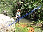
The thermal mineral waters emerge from the western side of the Pondoña Hill near an area called the Pailón where the “Rio Blanco” is born. This area is characterized by its cloud forest and a rich vegetation. The red mud is found near the mineral springs and is very good for the skin, apply it , let it dry, and wash it! It will leave your skin very soft and smooth to the touch, it is believed to have rejuvenating power.
Chaupisacha
Originally a research area set by the ministry of ambient a dense cloud forest area near the north-west side of the White River. Now there is a private farm and some old limestone kilns abandoned a hundred years ago. A dirt road access the farm and it ends near the farm houses where the foot trail continues to the community of Los Reales. There is abundant flora and fauna typical of 1800 meters altitude.
Los Reales
It is a very small isolated town with a population of eight families and a one-teacher school with eighteen children. The inhabitants engage in agriculture for their livelihood. There is access by foot or by horse from Chaupisacha, Infiernilo or Tanlagua.
Niebli 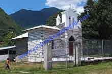
Is a small town where workers of the Niebli Farm settled; this farm originally belonged to the Order of the Jesuits and produces sugar cane alcohol since 75 years ago when the private owners installed the first industrial distillery in Ecuador. The farm also produces highland coffee and has grazing cattle.
Infiernillo
Is a semiarid area with a dirt road access that leads to the “Rio Blanco” (White River). Its name meaning “small hell”, probably comes from six huge limestone kilns that use to burn day and night to produce large quantities of lime. At the edge of the road there are many guava trees, orange, and cherimoya tress that ripen in July. The road reaches the Rio Blanco and then narrows to a foot trail that leads to a few small farms. On the other side of the river the trail almost disappears due to the constant dirt and sand that fall from the eroded mountain. Later the trail opens up to a dirt road that has car access that begins near the Tanlagua farm. Most of the families in this area also send their children to the Los Reales School. 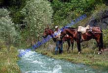
There are many more wonderful places, come and discover them!!
Tel: (593) 0999466636 - 0991914333
Phone:
593-999466636
593-991914333
Mail:![]()
Copyright © 2006 - 2016 Pululahua Hostal
Link to local weather stations INAMHI
